Discover our new guide on digital twins, BIM, Utility Network and infrastructure networks in Morocco. It also includes an interactive app to simulate a water network break.
GeoAI: AI Agents for GIS — A Complete Technical Guide | Kharita
GeoAIEnglish··32 min read·By Granpa GIS
GeoAI: AI Agents for GIS — A Complete Technical Guide
A comprehensive technical guide to AI agents for Geographic Information Systems (GIS). Covers three-tier agent architecture, ReAct and Multi-Agent design patterns, Model Context Protocol (MCP) tool integration, and full code implementations with LangGraph and CrewAI. Includes 7 professional architecture diagrams, GIS tool function schemas, and real-world use cases for disaster response, urban planning, environmental monitoring, and infrastructure inspection. Production-ready Python code for building autonomous geospatial AI agents.
GeoAI (Geospatial Artificial Intelligence) represents the convergence of geospatial data, geographic information systems (GIS), and artificial intelligence techniques including machine learning, deep learning, computer vision, and large language models (LLMs). The emergence of AI agents capable of planning, reasoning, and executing geospatial workflows autonomously marks a paradigm shift in how spatial analysis is conducted.
This guide provides a comprehensive technical reference for understanding, architecting, and implementing AI agents for GIS workflows. It covers architecture patterns, framework comparisons, code examples, and production-ready guidance based on the current state of the industry in 2026.
Key Takeaways
Capability
Impact
Autonomous Spatial Analysis
AI agents can plan and execute multi-step geoprocessing workflows with minimal human intervention
Discussion
Comments
Natural Language to GIS
Users can interact with GIS systems through conversational interfaces without writing queries
Multi-Agent Orchestration
Teams of specialized agents collaborate on complex geospatial tasks
Democratized Access
Non-GIS experts can access powerful spatial analysis capabilities
Workflow Automation
Repetitive geoprocessing tasks are automated, reducing analysis time by 70-90%
2. What is GeoAI?
Definition
GeoAI is the integration of geospatial data and artificial intelligence techniques within GIS platforms to automate, enhance, and scale spatial analysis. It encompasses a wide range of capabilities, from object detection in imagery and 3D scenes to natural language-powered assistants and predictive modeling.
Evolution of AI in GIS
1980s ──► Command-line GIS Systems
   │
1990s ──► Graphical User Interfaces (GUI) + Desktop GIS
   │
2000s ──► Web GIS + Cloud Computing + Mobile Platforms
   │
2010s ──► Machine Learning for spatial analysis & image classification
   │
Late 2010s ──► Deep Learning embedded in core GIS workflows
   │
2020s ──► Large Language Models (LLMs) + Computer Vision
   │
2024-2026 ──► AI Agents: Autonomous, multi-step geospatial workflow orchestration
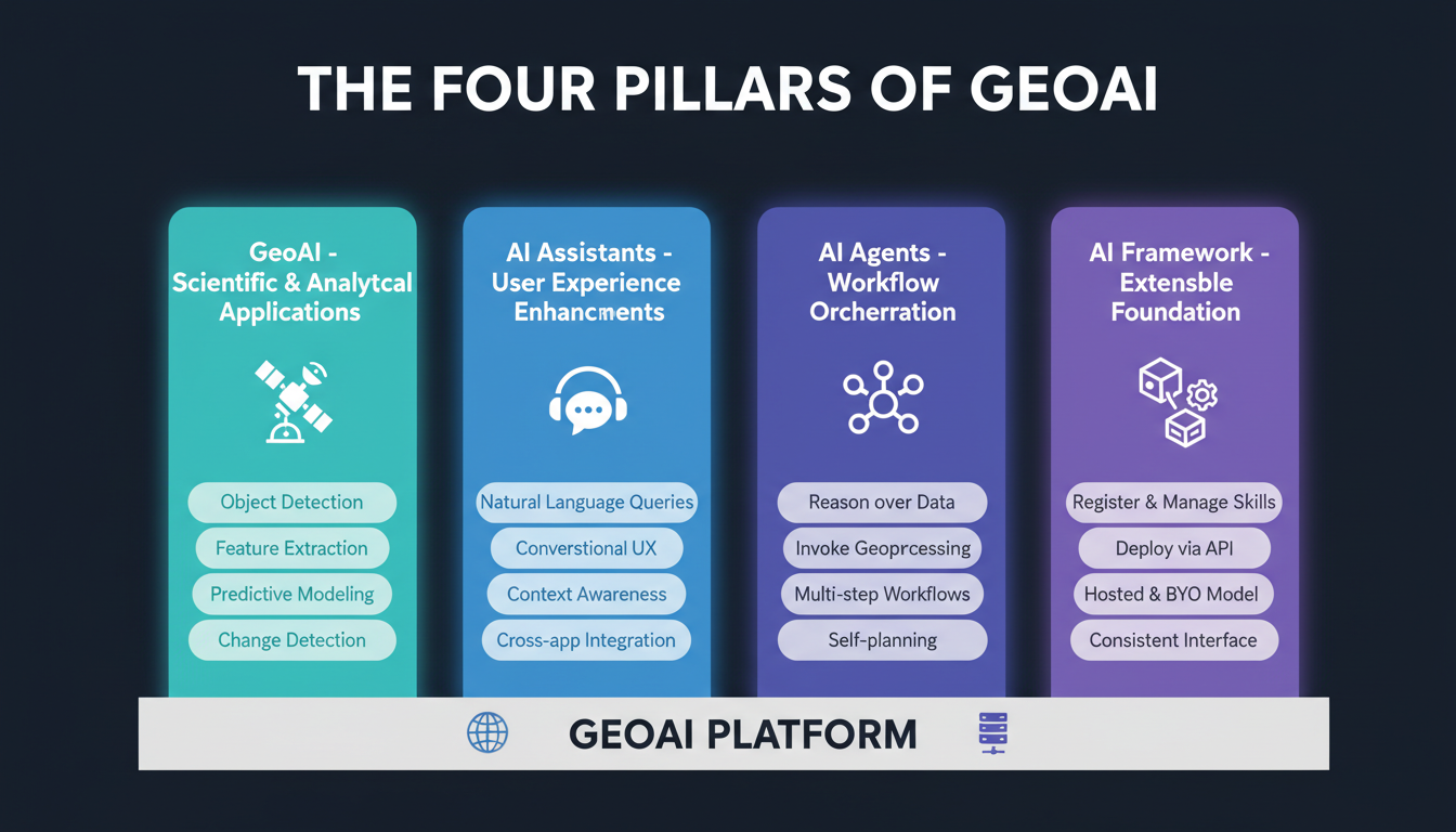
The Four Pillars of GeoAI
3. Geospatial AI Agents: Core Concepts
What is a Geospatial AI Agent?
A geospatial AI agent is an autonomous or semi-autonomous software component that:
Perceives geospatial data (vector, raster, 3D, temporal)
Reasons about spatial relationships and domain context
Plans multi-step analysis workflows
Executes GIS tools, APIs, and geoprocessing services
Responds with actionable insights, maps, or derived datasets
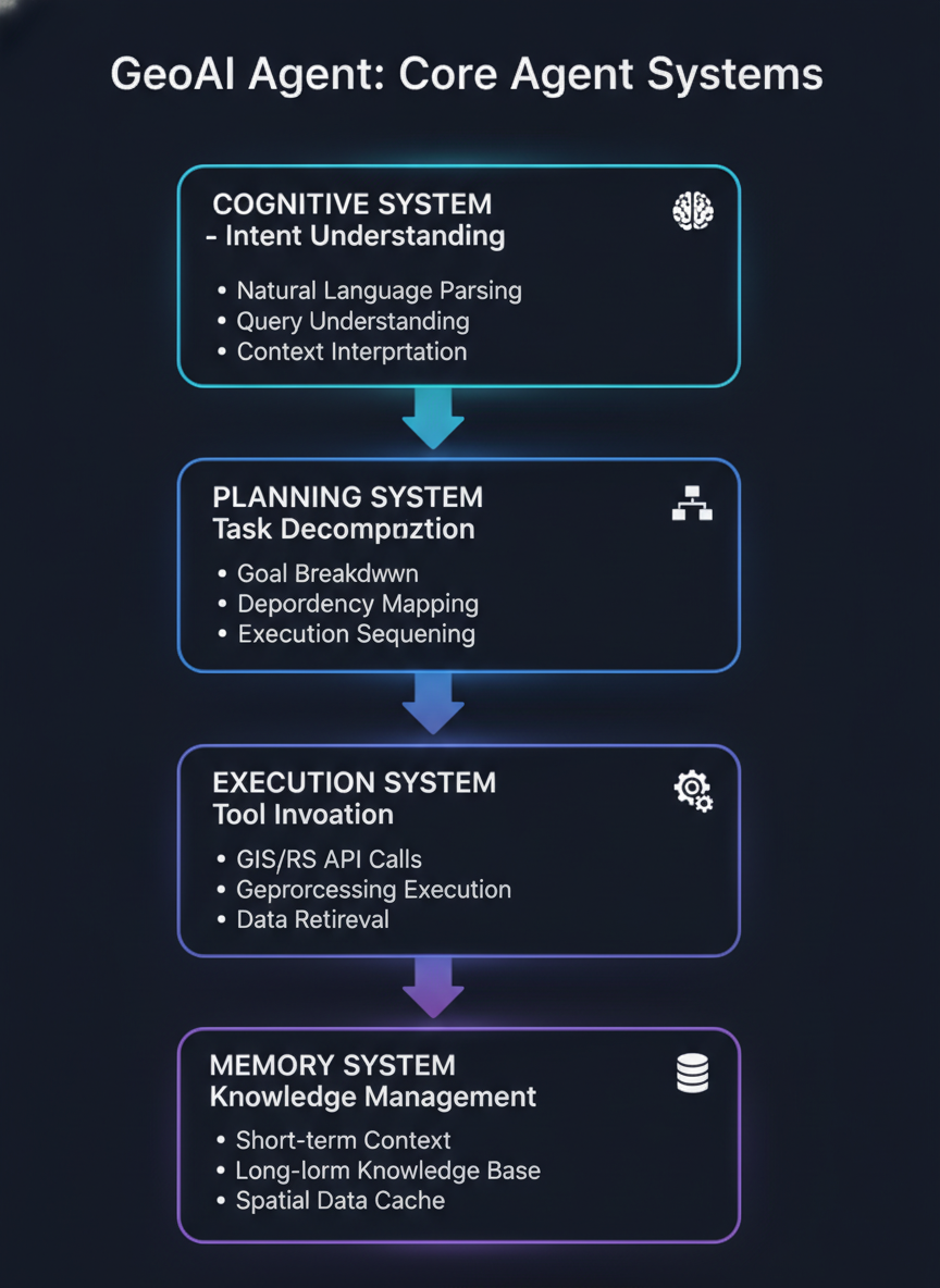
Core Agent Systems
Every geospatial AI agent consists of four interconnected systems:
Agent vs. Assistant vs. Traditional Script
Dimension
Traditional Script
AI Assistant
AI Agent
Autonomy
None (deterministic)
Low (guided)
High (self-directed)
Reasoning
None
LLM-powered
LLM + spatial reasoning
Tool Use
Hardcoded
Predefined skills
Dynamic tool selection
Adaptability
None
Limited context
Full replanning
Human Input
Batch execution
Interactive
Human-in-the-loop optional
Error Handling
Fail/Retry
Manual recovery
Self-correction
4. System Architecture & Design Patterns
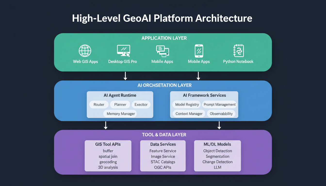
High-Level GeoAI Platform Architecture
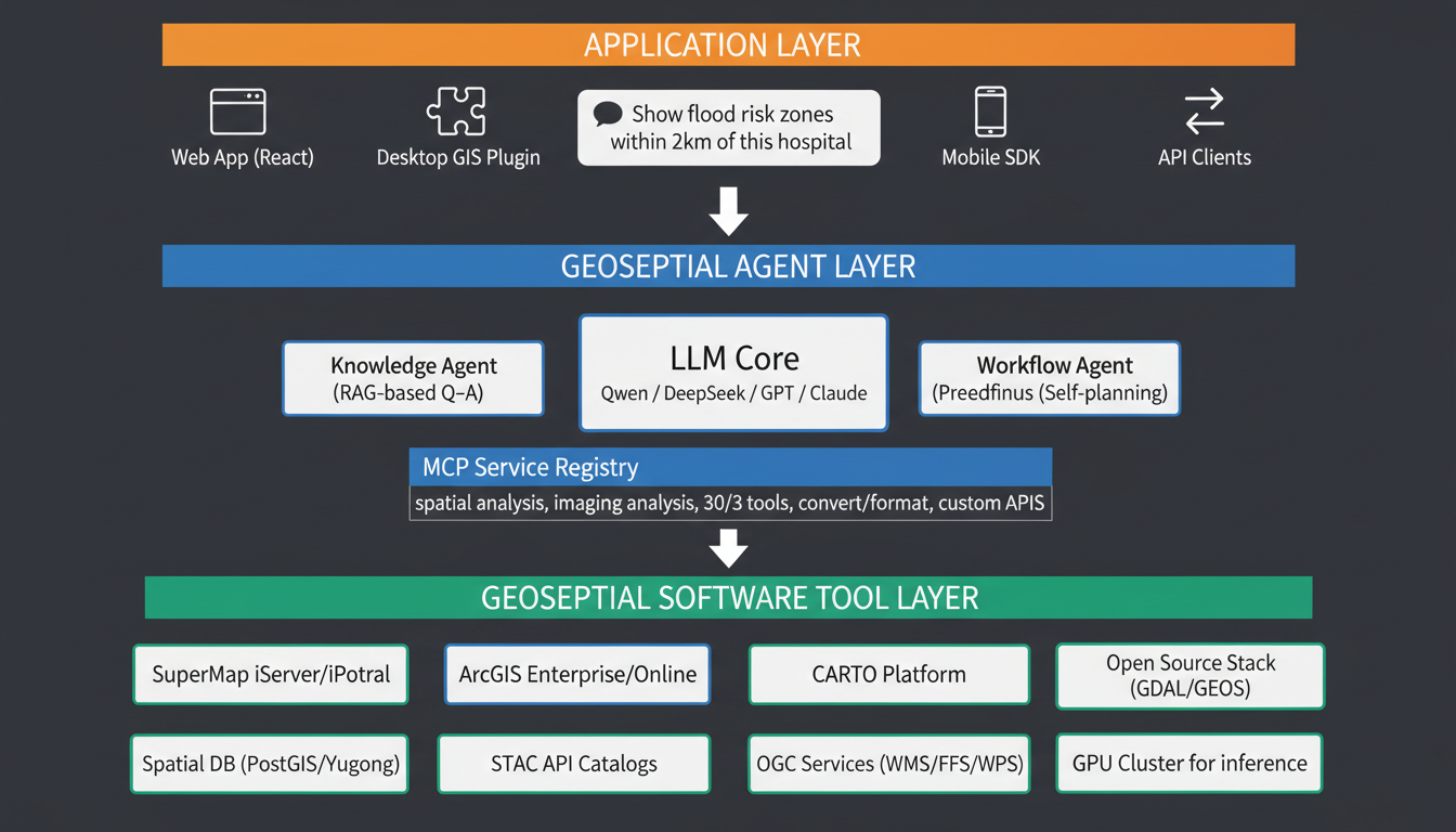
5. Three-Tier Geospatial Agent Architecture
A complete geospatial AI agent application follows a three-tier architecture:
6. Types of Geospatial AI Agents
6.1 Knowledge Agents (Level 1)
Purpose: Information retrieval and Q&A with geospatial domain knowledge.
Example Use Case: Real estate registration intelligent Q&A system delivering professional-grade precision in single-turn and multi-turn dialogues.
Strengths: Broad applicability, mature, high accuracy for information retrieval.
Limitations: No execution capabilities; cannot perform actual geoprocessing.
6.2 Workflow Agents (Level 2)
Purpose: Execute predefined geoprocessing workflows guided by natural language.
Architecture:
Stage
Action
Description
1
Parse Intent
LLM extracts intent and parameters from natural language
Example Use Case: In SuperMap iDesktopX, users input commands like "Create a thematic map segmented by national population data" and the system displays results immediately. Further commands can generate labeled thematic maps or statistical charts.
Strengths: High success rate for complex tasks, production-ready, hybrid human-AI control.
Limitations: Requires predefined workflows; less flexible than autonomous agents.
6.3 Autonomous Agents (Level 3)
Purpose: Self-directed task planning and execution with iterative optimization.
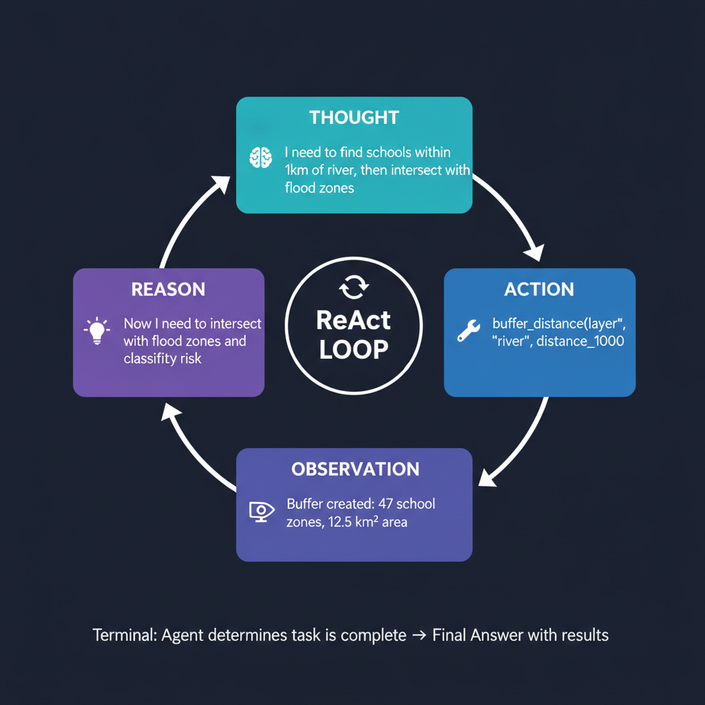
Architecture (ReAct Pattern):
User Query → Task Planning → [Execute → Observe → Reason] (loop) → Final Output
Operational Logic:
Task Planning: Decompose high-level goal into actionable steps
Step Execution: Execute the current step using available tools
Example Use Case: Autonomous landslide risk assessment combining DEM analysis, rainfall data, soil properties, and land cover classification without predefined workflow.
Best For: Complex, long-running geospatial workflows requiring state management and precise control over data flow.
Architecture Pattern:
# LangGraph-based GeoAI Agent (Conceptual)
from langgraph.graph import StateGraph, START, END
from langchain_core.tools import tool

# State definition
class GeoAgentState(TypedDict):
    messages: Annotated[list, operator.add]
    spatial_data: dict
    analysis_results: dict
    active_tools: list[str]

# Tool definitions
@tool
def buffer_geometry(layer_name: str, distance: float) -> str:
    """Buffer a geometry layer by specified distance."""
    ...

@tool
def spatial_join(target_layer: str, join_layer: str) -> str:
    """Perform spatial join between two layers."""
    ...

@tool
def clip_raster(raster_path: str, bounds: tuple) -> str:
    """Clip raster to specified bounds."""
    ...

# Graph construction
workflow = StateGraph(GeoAgentState)
workflow.add_node("understand_query", understand_node)
workflow.add_node("plan_analysis", planning_node)
workflow.add_node("execute_gis", ToolNode(gis_tools))
workflow.add_node("evaluate_results", evaluation_node)

workflow.add_edge(START, "understand_query")
workflow.add_conditional_edges("understand_query", route_to_planning)
workflow.add_conditional_edges("plan_analysis", route_to_execution)
workflow.add_edge("execute_gis", "evaluate_results")
workflow.add_conditional_edges("evaluate_results", should_continue)

geo_agent = workflow.compile()
7.3 CrewAI for GeoAI
Strengths:
Fastest prototyping (working multi-agent in <100 lines)
Role-based abstraction maps well to GIS team structures
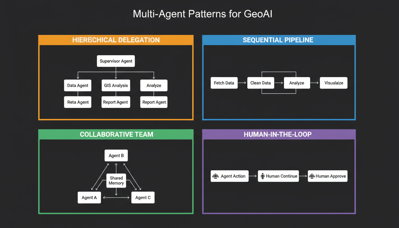
Sequential and Hierarchical execution patterns
YAML configuration for non-developers
Best For: Pipeline workflows where different agents own different phases (data acquisition → processing → analysis → visualization).
Architecture Pattern:
# CrewAI Geo Crew Configuration (YAML)
agents:
  data_acquisition_agent:
    role: "Geospatial Data Acquisition Specialist"
    goal: "Find and retrieve the most relevant spatial datasets for analysis"
    backstory: "You are an expert in geospatial data sources, STAC catalogs, and API endpoints. You know exactly where to find elevation data, satellite imagery, and vector datasets."
    tools:
      - stac_search
      - wfs_query
      - data_download

  spatial_analyst:
    role: "Senior Spatial Analyst"
    goal: "Perform rigorous geospatial analysis to extract meaningful insights"
    backstory: "You are a GIS professional with 15 years of experience in spatial analysis, geoprocessing, and cartography."
    tools:
      - buffer_tool
      - overlay_analysis
      - interpolation
      - cluster_analysis

  cartographer:
    role: "Professional Cartographer"
    goal: "Create beautiful, informative maps that communicate findings clearly"
    backstory: "You are an award-winning cartographer specializing in thematic mapping and data visualization."
    tools:
      - thematic_map
      - symbolization
      - layout_design

tasks:
  acquire_data:
    description: "Retrieve DEM, land cover, and infrastructure data for {study_area}"
    agent: data_acquisition_agent
    expected_output: "List of acquired datasets with metadata"

  perform_analysis:
    description: "Analyze flood risk using acquired datasets"
    agent: spatial_analyst
    context: [acquire_data]
    expected_output: "Risk assessment results with statistics"

  create_map:
    description: "Generate final risk map with legend and annotations"
    agent: cartographer
    context: [perform_analysis]
    expected_output: "Publication-ready map document"
7.4 AutoGen for GeoAI
Strengths:
Native multi-agent conversation
Mix-and-match LLM support (Claude for reasoning + GPT-4o for tools)
Built-in sandboxed code execution
Asynchronous event-driven architecture
Best For: Research automation, iterative analysis, and scenarios where agents need to collaborate dynamically.
7.5 Strands Agents / GeoAgent (Geospatial-Native)
GeoAgent is a shared AI agent layer specifically built for geospatial Python packages, live map widgets, and QGIS plugins.
import leafmap
from geoagent import for_leafmap

# Create map and bind agent
m = leafmap.Map()
agent = for_leafmap(m)

# Natural language geospatial interaction
resp = agent.chat("Add a marker for Knoxville and zoom to it.")
resp = agent.chat("Load the STAC catalog for Sentinel-2 and display imagery.")

# Display map
m
8. Tool Systems: MCP, RAG & Function Calling
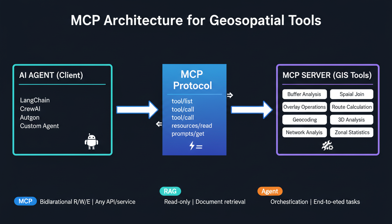
8.1 Model Context Protocol (MCP)
MCP is an open protocol that standardizes how AI agents connect to external tools and services. It provides bidirectional communication (read + write + execute).
MCP vs RAG vs Agents:
Dimension
MCP
RAG
AI Agent
Purpose
Connect LLM to tools
Retrieve knowledge
Orchestrate workflows
Direction
Bidirectional (R/W/E)
Read-only
Orchestration
Scope
Any API/tool/service
Document retrieval
End-to-end task
Analogy
The "how" (connection)
The "what" (knowledge)
The "who" (orchestrator)
8.2 RAG for Geospatial Knowledge
Retrieval-Augmented Generation grounds agent responses in domain-specific geospatial knowledge.
"""
GeoAI Agent - Complete Implementation
A production-ready geospatial AI agent using LangGraph
"""

import operator
from typing import Annotated, TypedDict, Sequence
from langchain_core.messages import BaseMessage, HumanMessage, SystemMessage, ToolMessage
from langgraph.graph import StateGraph, START, END
from langchain_openai import ChatOpenAI
from langchain_core.tools import tool
from langgraph.prebuilt import ToolNode
import json

# ============================================================================
# STATE DEFINITION
# ============================================================================

class GeoAgentState(TypedDict):
    """State object flowing through the agent graph."""
    messages: Annotated[Sequence[BaseMessage], operator.add]
    active_skills: list[str]
    spatial_context: dict
    execution_log: list[dict]
    requires_human: bool

# ============================================================================
# GEOSPATIAL TOOLS
# ============================================================================

@tool
def buffer_analysis(
    layer_name: str,
    distance: float,
    unit: str = "meters",
    dissolve: bool = False
) -> str:
    """
    Create buffer zones around features in a layer.

    Args:
        layer_name: Name of the input feature layer
        distance: Buffer distance value
        unit: Unit of distance (meters, kilometers, feet, miles)
        dissolve: Whether to dissolve overlapping buffers

    Returns:
        Summary of buffer operation results
    """
    # Implementation would call ArcPy, GeoPandas, or GIS API
    result = {
        "operation": "buffer",
        "input_layer": layer_name,
        "distance": f"{distance} {unit}",
        "features_created": 47,
        "total_area_km2": 12.5,
        "dissolved": dissolve,
        "output_layer": f"{layer_name}_buffer_{distance}{unit[0]}"
    }
    return json.dumps(result, indent=2)

@tool
def spatial_intersection(layer_a: str, layer_b: str, output_name: str = None) -> str:
    """
    Compute geometric intersection between two layers.

    Args:
        layer_a: First input layer
        layer_b: Second input layer
        output_name: Optional output layer name

    Returns:
        Summary of intersection results
    """
    result = {
        "operation": "intersection",
        "layer_a": layer_a,
        "layer_b": layer_b,
        "features_output": 23,
        "output_layer": output_name or f"{layer_a}_intersect_{layer_b}"
    }
    return json.dumps(result, indent=2)

@tool
def extract_by_attribute(layer: str, field: str, operator: str, value) -> str:
    """
    Select features by attribute query.

    Args:
        layer: Input layer name
        field: Field name to query
        operator: Comparison operator (=, <>, <, >, <=, >=, LIKE)
        value: Value to compare against

    Returns:
        Summary of selected features
    """
    result = {
        "operation": "attribute_selection",
        "layer": layer,
        "query": f"{field} {operator} {value}",
        "features_selected": 156,
        "total_features": 500
    }
    return json.dumps(result, indent=2)

@tool
def zonal_statistics(zone_layer: str, value_raster: str, statistics: list) -> str:
    """
    Calculate statistics for raster values within zone polygons.

    Args:
        zone_layer: Zone polygon layer name
        value_raster: Input raster dataset path
        statistics: List of statistics (mean, max, min, sum, std, count)

    Returns:
        Statistics table as JSON
    """
    result = {
        "operation": "zonal_statistics",
        "zone_layer": zone_layer,
        "value_raster": value_raster,
        "statistics": {
            stat: round(10 + hash(f"{zone_layer}{stat}") % 90, 2)
            for stat in statistics
        }
    }
    return json.dumps(result, indent=2)

@tool
def generate_map(layer: str, attribute: str, method: str = "natural_breaks", classes: int = 5) -> str:
    """
    Generate a thematic map from a layer.

    Args:
        layer: Layer to visualize
        attribute: Attribute field to map
        method: Classification method
        classes: Number of classes

    Returns:
        Map generation summary
    """
    result = {
        "operation": "thematic_map",
        "layer": layer,
        "attribute": attribute,
        "classification": method,
        "classes": classes,
        "map_url": f"/maps/{layer}_{attribute}_{method}.html",
        "legend": f"Generated {classes}-class {method} legend for {attribute}"
    }
    return json.dumps(result, indent=2)

# Tool registry
GIS_TOOLS = [buffer_analysis, spatial_intersection, extract_by_attribute,
             zonal_statistics, generate_map]

# ============================================================================
# LLM INITIALIZATION
# ============================================================================

# Primary reasoning model (capable)
llm = ChatOpenAI(model="gpt-4o", temperature=0)
llm_with_tools = llm.bind_tools(GIS_TOOLS)

# ============================================================================
# GRAPH NODES
# ============================================================================

def reasoning_node(state: GeoAgentState):
    """Central intelligence node - analyzes state and determines next action."""
    response = llm_with_tools.invoke(state["messages"])
    return {
        "messages": [response],
        "execution_log": state.get("execution_log", []) + [{
            "node": "reasoning",
            "tool_calls": response.tool_calls if hasattr(response, 'tool_calls') else []
        }]
    }

def planning_node(state: GeoAgentState):
    """Breaks down complex geospatial tasks into executable steps."""
    planner_prompt = """You are a geospatial task planner. Given a user request,
    break it down into specific GIS operations.

    Available operations:
    - buffer_analysis: Create buffer zones
    - spatial_intersection: Find overlapping areas
    - extract_by_attribute: Filter by attributes
    - zonal_statistics: Calculate raster stats by zone
    - generate_map: Create thematic visualizations

    Provide your plan as a numbered list of tool calls with specific parameters."""

    messages = state["messages"] + [SystemMessage(content=planner_prompt)]
    response = llm.invoke(messages)
    return {"messages": [response]}

def human_review_node(state: GeoAgentState):
    """Human-in-the-loop checkpoint for critical operations."""
    return {"requires_human": True, "messages": state["messages"]}

# ============================================================================
# ROUTING LOGIC
# ============================================================================

def router(state: GeoAgentState) -> str:
    """Inspects last message to determine next operational node."""
    last_message = state["messages"][-1]

    # Route to tool execution if tool calls present
    if hasattr(last_message, 'tool_calls') and last_message.tool_calls:
        return "execute_tools"

    # Check for completion signal
    content = last_message.content.lower() if hasattr(last_message, 'content') else ""
    if "final answer" in content or "task complete" in content:
        return "end"

    # Check if human review needed
    if state.get("requires_human", False):
        return "human_review"

    return "end"

def should_human_review(state: GeoAgentState) -> str:
    """Determine if destructive or expensive operations need approval."""
    last_message = state["messages"][-1]
    if hasattr(last_message, 'tool_calls'):
        for tc in last_message.tool_calls:
            if tc.get("name") in ["buffer_analysis", "spatial_intersection"]:
                # Auto-approve standard operations
                return "execute_tools"
    return "execute_tools"

# ============================================================================
# GRAPH CONSTRUCTION
# ============================================================================

workflow = StateGraph(GeoAgentState)

# Add nodes
workflow.add_node("reason", reasoning_node)
workflow.add_node("plan", planning_node)
workflow.add_node("execute_tools", ToolNode(GIS_TOOLS))
workflow.add_node("human_review", human_review_node)

# Define edges
workflow.add_edge(START, "reason")

# Conditional routing from reasoning
workflow.add_conditional_edges(
    "reason",
    router,
    {
        "execute_tools": "execute_tools",
        "human_review": "human_review",
        "end": END
    }
)

# Return paths
workflow.add_edge("execute_tools", "reason")
workflow.add_edge("human_review", "reason")
workflow.add_edge("plan", "reason")

# Compile
geo_agent = workflow.compile()

# ============================================================================
# USAGE EXAMPLE
# ============================================================================

if __name__ == "__main__":
    # Example query
    query = """
    I need to identify flood risk areas for schools near the river.
    1. Find all schools within 500 meters of the river
    2. Create 500m buffers around the river
    3. Intersect buffers with school locations
    4. Generate a risk map
    """

    initial_state = {
        "messages": [HumanMessage(content=query)],
        "active_skills": [],
        "spatial_context": {},
        "execution_log": [],
        "requires_human": False
    }

    result = geo_agent.invoke(initial_state)
    print("Agent Response:")
    print(result["messages"][-1].content)
10.2 CrewAI Multi-Agent Geospatial Team
"""
GeoAI Crew - Multi-Agent Geospatial Analysis Team
Uses CrewAI for collaborative spatial analysis
"""

from crewai import Agent, Task, Crew, Process
from crewai.tools import tool
import os

# ============================================================================
# TOOLS
# ============================================================================

@tool
def search_stac_catalog(query: str, bbox: list, date_range: str) -> str:
    """Search STAC catalogs for satellite imagery."""
    return f"Found 12 Sentinel-2 scenes for {query} in bbox {bbox} from {date_range}"

@tool
def run_geoprocessing(tool_name: str, inputs: dict) -> str:
    """Execute a geoprocessing tool."""
    return f"Executed {tool_name} with inputs: {inputs}. Output: result.shp"

@tool
def classify_land_cover(image_path: str, model: str) -> str:
    """Run land cover classification on imagery."""
    return f"Classified {image_path} using {model}. 8 classes identified."

@tool
def generate_report(analysis_results: str, template: str) -> str:
    """Generate analysis report from results."""
    return f"Report generated using {template}. Contains: {analysis_results}"

# ============================================================================
# AGENTS
# ============================================================================

data_specialist = Agent(
    role="Geospatial Data Specialist",
    goal="Acquire and prepare the highest quality spatial data for analysis",
    backstory="""You are an expert geospatial data engineer with 10+ years of experience
    in remote sensing, satellite imagery, and spatial data infrastructure. You know every
    STAC catalog, OGC service, and geospatial API. You excel at finding, downloading, and
    preprocessing spatial data for analysis workflows.""",
    tools=[search_stac_catalog],
    verbose=True,
    allow_delegation=False
)

spatial_analyst = Agent(
    role="Senior Spatial Analyst",
    goal="Perform rigorous geospatial analysis to extract actionable insights",
    backstory="""You are a senior GIS analyst specializing in environmental modeling,
    spatial statistics, and geoprocessing. You have deep expertise in raster analysis,
    vector operations, and spatial modeling. You always validate your results and document
    your methodology thoroughly.""",
    tools=[run_geoprocessing, classify_land_cover],
    verbose=True,
    allow_delegation=False
)

report_writer = Agent(
    role="Geospatial Report Writer",
    goal="Create clear, comprehensive reports that communicate findings effectively",
    backstory="""You are a technical writer specializing in geospatial analysis documentation.
    You transform complex spatial analysis results into clear, actionable reports with
    beautiful maps and visualizations. Your reports are used by decision-makers at all levels.""",
    tools=[generate_report],
    verbose=True,
    allow_delegation=False
)

# ============================================================================
# TASKS
# ============================================================================

task_acquire_data = Task(
    description="""
    Search for and acquire satellite imagery for the study area (bounding box:
    [-95.5, 29.5, -95.0, 30.0]) covering January-June 2024.
    Find Sentinel-2 L2A products with \<10% cloud cover.
    Also search for elevation data (DEM) and land cover reference data.
    Return a complete inventory of available datasets with their IDs and metadata.
    """,
    agent=data_specialist,
    expected_output="A structured list of all acquired datasets with IDs, dates, and quality metrics"
)

task_analyze = Task(
    description="""
    Using the acquired satellite imagery, perform the following analysis:
    1. Preprocess imagery (atmospheric correction, cloud masking)
    2. Calculate NDVI vegetation index
    3. Perform land cover classification using supervised classification
    4. Identify areas of vegetation change between time periods
    5. Generate statistics: total area by land cover class, change detection summary

    Document all parameters and methods used.
    """,
    agent=spatial_analyst,
    context=[task_acquire_data],
    expected_output="Analysis results with methodology documentation and key statistics"
)

task_report = Task(
    description="""
    Create a comprehensive geospatial analysis report including:
    1. Executive summary of findings
    2. Methodology section with all parameters
    3. Results with tabulated statistics
    4. Visual description of map outputs
    5. Recommendations based on analysis

    Format as a professional technical report suitable for stakeholder review.
    """,
    agent=report_writer,
    context=[task_analyze],
    expected_output="Complete technical report in markdown format with all sections"
)

# ============================================================================
# CREW EXECUTION
# ============================================================================

crew = Crew(
    agents=[data_specialist, spatial_analyst, report_writer],
    tasks=[task_acquire_data, task_analyze, task_report],
    process=Process.sequential,
    verbose=True
)

if __name__ == "__main__":
    result = crew.kickoff()
    print("\n" + "="*60)
    print("FINAL REPORT")
    print("="*60)
    print(result)
10.3 GeoAgent with Live Map Integration
"""
GeoAgent Live Map Example
Interactive geospatial AI agent bound to a live map widget
"""

import leafmap
from geoagent import for_leafmap, GeoAgentConfig

# Create map
m = leafmap.Map(center=[35.9606, -83.9207], zoom=10)

# Configure agent with specific provider
config = GeoAgentConfig(
    provider="openai",
    model="gpt-4o",
    temperature=0.1
)

# Bind agent to map
agent = for_leafmap(m, config=config)

# Interactive geospatial queries
queries = [
    "Add a marker for Knoxville, Tennessee and zoom to it",
    "Change the basemap to satellite imagery",
    "Load the OpenStreetMap buildings layer for this area",
    "Set the opacity of the buildings layer to 0.6",
    "Add a buffer of 1km around the Knoxville marker",
    "List all layers currently on the map",
    "Save the current map view as map_export.png"
]

# Execute queries
for query in queries:
    print(f"\n🗣️  User: {query}")
    response = agent.chat(query)
    print(f"🤖 Agent: {response.answer_text}")

# Display interactive map
m
Trusted AI principles: Security, Privacy, Transparency, Fairness, Reliability, Accountability
12.2 CARTO
Feature
Description
AI Agents
Public preview, natural language map interaction
Context Layer
Automatic map configuration, tool definitions
Agent Configuration Assistant
Conversational agent setup
MCP Tools
CARTO MCP Server for geospatial operations
12.3 SuperMap AgentX Server
Feature
Specification
LLM Support
Qwen series, DeepSeek series
MCP Tools
200+ operators (iServer), 60+ operators (iPortal)
Agent Types
Knowledge, Workflow, Autonomous
Architecture
x86, ARM (Kunpeng), multi-OS
Database
Yugong Spatial Database (co-developed with Huawei)
12.4 Open Source Ecosystem
Project
Description
Link
GeoAgent
Shared agent layer for geospatial Python
github.com/opengeos/GeoAgent
GeoAI
Python package for AI + geospatial analysis
opengeoai.org
Leafmap
Interactive mapping with AI integration
leafmap.org
TorchGeo
Deep learning for geospatial data
torchgeo.readthedocs.io
GeoAI-ML
ML toolkit for ArcGIS / open source
esri.github.io/geoai-ml
13. Building Your First GeoAI Agent
Step-by-Step Guide
Step 1: Define Your Use Case
├── What geospatial problem are you solving?
├── Who are the users?
├── What data sources are needed?
└── What is the desired output?

Step 2: Choose Your Architecture
├── Single agent or multi-agent?
├── Knowledge, Workflow, or Autonomous?
├── Which framework (LangChain, CrewAI, AutoGen, Custom)?
└── LLM provider (OpenAI, Anthropic, Local)?

Step 3: Design Your Tools
├── List all GIS operations needed
├── Define tool schemas (name, params, returns)
├── Implement tool functions
└── Register with agent

Step 4: Build Context Layer
├── Data catalog with field descriptions
├── Spatial reference system definitions
├── Domain knowledge (RAG or fine-tuning)
└── Example queries and expected outputs

Step 5: Implement Agent Logic
├── Define state management
├── Set up routing/decision logic
├── Add memory and context handling
└── Configure error handling and retries

Step 6: Add Safety & Guardrails
├── Confirmation for destructive operations
├── Token and cost limits
├── Human-in-the-loop checkpoints
└── Output validation

Step 7: Test & Iterate
├── Unit tests for individual tools
├── Integration tests for workflows
├── User acceptance testing
└── Performance optimization

Step 8: Deploy & Monitor
├── API endpoint or web app
├── Logging and observability
├── Usage analytics
└── Continuous improvement loop
14. Production Considerations
14.1 Cost Management
Strategy
Implementation
Savings
Model Tiering
Use GPT-4o for reasoning, GPT-4o-mini for execution
50-70%
Tool Limiting
Start with 3-5 tools, expand as needed
30-40%
Caching
Cache frequent queries and results
20-30%
Max Iterations
Set hard limits on agent loops
Prevents runaway costs
Async Processing
Queue expensive operations
Better resource use
14.2 Reliability Patterns
┌─────────────────────────────────────────────────────────────────┐
│                   PRODUCTION SAFEGUARDS                          │
├─────────────────────────────────────────────────────────────────┤
│                                                                  │
│  1. OBSERVABILITY                                                │
│     ├── Log every LLM call with prompt and response              │
│     ├── Track tool invocations and results                       │
│     ├── Monitor token usage and costs                            │
│     └── Measure latency per operation                            │
│                                                                  │
│  2. ERROR HANDLING                                               │
│     ├── Retry with exponential backoff                           │
│     ├── Circuit breaker for failing tools                        │
│     ├── Graceful degradation (partial results)                   │
│     └── Fallback to human escalation                             │
│                                                                  │
│  3. SAFETY GUARDRAILS                                            │
│     ├── Confirmation gates for destructive ops                   │
│     ├── Rate limiting on tool calls                              │
│     ├── Input sanitization and validation                        │
│     └── Output schema validation                                 │
│                                                                  │
│  4. HUMAN-IN-THE-LOOP                                            │
│     ├── Review checkpoints for critical analysis                 │
│     ├── Approval workflow for data publication                   │
│     ├── Override capability for expert users                     │
│     └── Feedback collection for improvement                      │
│                                                                  │
└─────────────────────────────────────────────────────────────────┘