
GIS careers in Morocco: the skills employers ask for
303 competitions, 27 job descriptions, 909 LinkedIn listings and thirty-seven years of satellite maps
What Moroccan employers really ask of GIS specialists and surveyors: where the State recruits, why the land registry is hiring, what job descriptions say, what the private sector wants, and where to train.
Loading the map…
1 / 15
GeoInsights
GIS careers in Morocco: the skills employers ask for
What does it take to work in GIS in Morocco? Rather than guess, we read what employers write: 303 public recruitment competitions in surveying and geomatics since 2012, 27 detailed job descriptions and 909 LinkedIn listings. Here is what they actually ask for.
2 / 15
A job in the field, and on screen
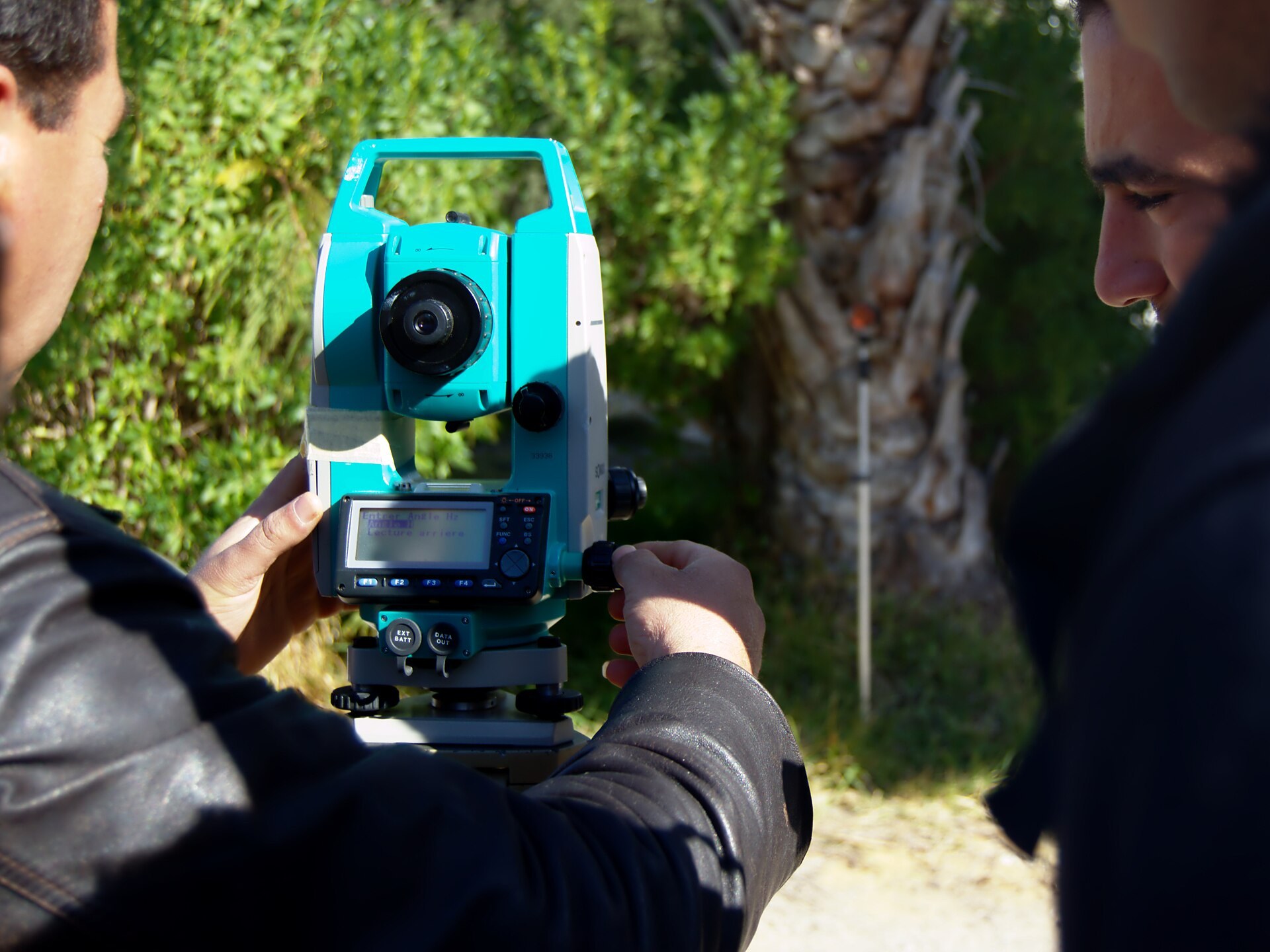
Behind the word "geomatics", two jobs. The surveyor measures, marks boundaries and checks: total station, GNSS, parcel plans. The GIS engineer builds databases, web maps and image analyses. Public competitions mostly recruit the first; the few private listings rather look for the second. Both produce the same thing: accurate geographic data.
3 / 15
Everywhere, not just in Rabat
Each column is a city where a local body — urban agency, utility, university — has opened a geomatics competition since 2012: 219 competitions in 30 cities, from Tangier to Dakhla. Casablanca has 19, Rabat 13, Agadir 12. Hover over a city in the chart: its column lights up. The other 84 come from national bodies that recruit for the whole country.
Source : Portail de l'emploi public (emploi-public.ma) — avis de concours, relevé Kharita (octobre 2012 – octobre 2026 (date limite de dépôt))
▸ See the data
| Casablanca | 19 |
|---|---|
| Rabat | 13 |
| Agadir | 12 |
| Berrechid | 11 |
| Beni Mellal | 11 |
| Settat | 10 |
| Larache | 10 |
| Oujda | 10 |
| Fez | 10 |
| Taza | 10 |
| Al Hoceima | 8 |
| Marrakesh | 8 |
4 / 15
From 4 cities to 30
In 2012, only four cities had opened a geomatics competition: Settat, Al Hoceima, Taza and Ouarzazate. Then urban agencies and utilities followed, one by one, all the way to Laayoune and Dakhla. By 2026, there are 30. The map replays the dated notices, year by year; the chart counts the cities.
Source : Portail de l'emploi public (emploi-public.ma) — avis de concours, relevé Kharita (2012–2026)
▸ See the data
| 2012 | 4 |
|---|---|
| 2013 | 7 |
| 2014 | 12 |
| 2015 | 19 |
| 2016 | 25 |
| 2017 | 26 |
| 2018 | 26 |
| 2019 | 28 |
| 2020 | 28 |
| 2021 | 28 |
| 2022 | 29 |
| 2023 | 29 |
| 2024 | 30 |
| 2025 | 30 |
| 2026 | 30 |
5 / 15
A fast-changing territory
Why so many competitions? Because the city grows faster than its plans. Around Casablanca, built-up and impervious surfaces rose from about 73 km² in 1985 to 200 km² in 2022, according to the GLC_FCS30D land-cover map: almost three times as much. Every housing estate, every road must be surveyed, marked out, registered and entered into the zoning plan.
Source : GLC_FCS30D (Zhang et al., Zenodo 8239305), jeu du catalogue Kharita — mesure Kharita (1985–2022)
▸ See the data
| 1985 | 73 |
|---|---|
| 1990 | 78 |
| 1995 | 83 |
| 2000 | 117 |
| 2001 | 122 |
| 2002 | 125 |
| 2003 | 133 |
| 2004 | 137 |
| 2005 | 139 |
| 2006 | 139 |
| 2007 | 139 |
| 2008 | 132 |
| 2009 | 140 |
| 2010 | 148 |
| 2011 | 152 |
| 2012 | 162 |
| 2013 | 171 |
| 2014 | 177 |
| 2015 | 179 |
| 2016 | 177 |
| 2017 | 180 |
| 2018 | 181 |
| 2019 | 185 |
| 2020 | 190 |
| 2021 | 200 |
| 2022 | 200 |
6 / 15
The land registry, first employer
From 2022 to 2026, competitions devoted solely to geomatics offered 424 posts, 252 of them at the ANCFCC — land registry, cadastre and mapping. The pace has changed: 23 posts a year on average from 2015 to 2021, 85 from 2022 to 2025. The agency is extending land registration, more than a million hectares in 2025: it takes surveyors to measure those parcels.
252posts
opened by the ANCFCC from 2022 to 2026, out of 424 in geomatics
Source : Portail de l'emploi public (emploi-public.ma) — 303 avis de concours en topographie et géomatique, et leurs fiches de poste, relevés le 8 octobre 2026
Source : Portail de l'emploi public (emploi-public.ma) — avis de concours, relevé Kharita (2015–2026)
▸ See the data
| ANCFCC | Other public bodies | |
|---|---|---|
| 2015 | 0 | 25 |
| 2016 | 0 | 13 |
| 2017 | 0 | 15 |
| 2018 | 0 | 25 |
| 2019 | 0 | 32 |
| 2020 | 0 | 16 |
| 2021 | 0 | 33 |
| 2022 | 65 | 34 |
| 2023 | 0 | 35 |
| 2024 | 72 | 35 |
| 2025 | 57 | 42 |
| 2026 | 58 | 26 |
7 / 15
What the job descriptions say
We read one by one the 27 descriptions attached to competitions from November 2024 to October 2026: 21 for surveyors, almost all from urban agencies, and 6 for GIS engineers. The foundation is shared: digital mapping, photogrammetry and imagery, planning rules, each in 23 descriptions. GIS is named in 19 out of 27, ArcGIS in 13, QGIS in 6.
Source : Portail de l'emploi public (emploi-public.ma) — avis de concours, relevé Kharita (novembre 2024 – octobre 2026)
▸ See the data
| Digital mapping | 85 |
|---|---|
| Photogrammetry, imagery | 85 |
| Planning regulations | 85 |
| Topographic surveys | 81 |
| Land tenure | 74 |
| GIS (named) | 70 |
| CAD (AutoCAD, Covadis) | 56 |
| ArcGIS | 48 |
| QGIS | 22 |
| MapInfo | 22 |
| Web mapping | 22 |
| English | 22 |
8 / 15
Two jobs, two toolkits
The urban-agency surveyor measures, checks and processes files: land tenure appears in 20 of 21 descriptions, CAD in 14. The GIS engineer builds systems: ArcGIS and QGIS in 5 of 6 descriptions, databases and SQL in 5, the web in all 6. No surveyor description asks for a database. Six descriptions show a trend, not a measurement.
Source : Portail de l'emploi public (emploi-public.ma) — avis de concours, relevé Kharita (novembre 2024 – octobre 2026)
▸ See the data
| Surveyor (21 descriptions) | GIS engineer (6 descriptions) | |
|---|---|---|
| Webmapping, web | 0 | 100 |
| Bases de données, SQL | 0 | 83 |
| QGIS | 5 | 83 |
| ArcGIS | 38 | 83 |
| Programmation | 0 | 50 |
| Levés topographiques | 95 | 33 |
| Réglementation d'urbanisme | 100 | 33 |
| Foncier | 95 | 0 |
9 / 15
AI enters public job descriptions
In Kenitra, the urban agency asks its survey engineer to master drones, laser scanning, BIM and 3D GIS; knowledge of artificial intelligence is "a plus". In Rabat, a GIS engineer description published in 2025 asks for Python and AI models applied to spatial data. These are still only two descriptions out of 27: fieldwork remains the foundation, but the tools are changing.
Official position
« Command of new technologies, such as laser-scanning hardware and software, BIM, 3D GIS, CIM, etc. Solid knowledge of artificial intelligence disciplines is a plus. »
10 / 15
The private sector: scarce, technical, in Casablanca
On LinkedIn, the catch is thin: sixteen searches return 909 listings in Morocco, and only 27 really ask for a geospatial skill. Eleven are UM6P postdocs; the rest come from engineering and construction, software, consulting and fibre optics. When the listing says where, it is almost always Casablanca or Mohammedia: 11 out of 16.
Source : LinkedIn — offres d'emploi publiques au Maroc, relevé Kharita (offres en ligne le 8 octobre 2026)
▸ See the data
| Research (UM6P) | 11 |
|---|---|
| Engineering, construction, mining | 5 |
| Software and data | 4 |
| Consulting and cooperation | 4 |
| Telecoms (fibre) | 3 |
11 / 15
What the private sector wants: data
These 27 listings are mostly about data: English is asked for in 13, remote sensing in 9, Python and AI in 7 each, QGIS in 6, ArcGIS in only 3. Elsewhere, the same trend: among 1,240 geospatial listings collected by GEO CAREERS from October 2025 to February 2026, Python appears in 27%, ahead of ArcGIS (12%) and SQL (9%).
Source : LinkedIn — offres d'emploi publiques au Maroc, relevé Kharita (offres en ligne le 8 octobre 2026)
▸ See the data
| English | 13 |
|---|---|
| Remote sensing, imagery | 9 |
| Python | 7 |
| AI, machine learning | 7 |
| QGIS | 6 |
| Databases, SQL | 5 |
| CAD (AutoCAD, Covadis) | 5 |
| ArcGIS | 3 |
| PostGIS | 3 |
12 / 15
Public, private: two shopping lists
Side by side, 27 public descriptions and 27 private listings. ArcGIS and CAD dominate the public side (48% and 56% of descriptions) but weigh little in the private sector (11% and 19%). English and AI go the other way. QGIS and SQL are asked for at the same level on both sides. On the map, the public sector recruits across the country; the private sector, around Casablanca.
Source : Portail de l'emploi public (fiches de poste) et LinkedIn (offres publiques au Maroc), relevés Kharita (fiches : novembre 2024 – octobre 2026 ; offres : en ligne le 8 octobre 2026)
▸ See the data
| Public job descriptions (27) | Private LinkedIn listings (27) | |
|---|---|---|
| ArcGIS | 48 | 11 |
| DAO (AutoCAD, Covadis) | 56 | 19 |
| QGIS | 22 | 22 |
| Bases de données, SQL | 19 | 19 |
| Anglais | 22 | 48 |
| IA | 7 | 26 |
13 / 15
Where to train
The training exists. IAV Hassan II, in Rabat, trains engineers in geomatics and surveying; EHTP, in Casablanca, opened its GIS track as early as 1998. Universities keep adding master's programmes, from Marrakesh (geomatics and territorial management, accredited in 2025) to Beni Mellal (environmental geomatics). The State aims for 100,000 digital talents trained a year by 2030.
1998
EHTP opens a GIS engineering track, with ENSG Paris
Source : Sinan et al., « Présentation de la filière SIG de l'EHTP », FIG Working Week, Marrakech, 2003
April 2023
The HCP starts mapping the census: GPS tablets and satellite images
About 38,000 districts drawn from April 2023 to March 2024.
Source : MAP — « RGPH 2024 : les travaux cartographiques ont permis le découpage du territoire national en environ 38 000 districts de recensement »
September 2024
Digital Morocco 2030 targets 100,000 digital talents trained a year
Source : Hespress — « Digital Morocco 2030 : 100 milliards de dirhams et 240 000 emplois pour dynamiser l'économie numérique »
2025
"Geomatics and territorial management" master accredited in Marrakesh
Source : FLSH Marrakech (Université Cadi Ayyad) — master Géomatique et gestion territoriale, accrédité en 2025
2025
The ANCFCC registers more than 1.05 million hectares
Source : FNH — « ANCFCC : chiffre d'affaires record de près de 11 milliards de DH et 7,5 milliards reversés à l'État en 2025 »
14 / 15
Explore the map
The map is yours: turn layers on or off, hover over a city to read its figures, zoom in on Casablanca to see the 2022 built-up surfaces.
15 / 15
Sources and method
Everything this story states comes from here: the data tables, the references cited and the catalogue datasets, with their licence and date.
Data
Portail de l'emploi public (emploi-public.ma) — avis de concours, relevé Kharita
Period : 2015–2026Licence : Avis publics de l'administrationUpdated : 2026-10-08
Posts in competitions devoted solely to geomatics or surveying, by year of application deadline. 2026: up to 23 October.
Sites des établissements (IAV Hassan II, Université Cadi Ayyad, FST Béni Mellal) ; FIG 2003 pour l'EHTP ; LinkedIn pour l'UM6P
Approximate campus locations.
GLC_FCS30D (Zhang et al., Zenodo 8239305), jeu du catalogue Kharita — mesure Kharita
Period : 1985–2022Licence : CC BY 4.0Updated : 2026-10-08
Pixels of class 190 (impervious and built-up surfaces) counted in a 32 km by 25 km frame around Casablanca and Mohammedia (7.75° W – 7.40° W, 33.45° N – 33.68° N), on the catalogue tiles at zoom 12 (about 32 m), nearest neighbour. Before 2000, one map every five years. From one year to the next, the classification varies by a few km²: the trend reads over time.
LinkedIn — offres d'emploi publiques au Maroc, relevé Kharita
Period : offres en ligne le 8 octobre 2026Licence : Annonces publiquesUpdated : 2026-10-08
Location given by the listing. The 11 listings without a city (UM6P postdocs) are not placed.
Period : fiches : novembre 2024 – octobre 2026 ; offres : en ligne le 8 octobre 2026Licence : Avis publics de l'administrationUpdated : 2026-10-08
A skill counts when the document names it. The 27 job descriptions of public competitions and the 27 private listings kept on LinkedIn were read with the same rule; only skills recorded under the same name on both sides are shown.
References
- Portail de l'emploi public (emploi-public.ma) — 303 avis de concours en topographie et géomatique, et leurs fiches de poste, relevés le 8 octobre 2026 · 2026-10-08
- LinkedIn — 909 offres publiques au Maroc pour seize mots-clés géospatiaux, relevées et relues le 8 octobre 2026 · 2026-10-08
- Agence urbaine de Kénitra-Sidi Kacem-Sidi Slimane — fiche de poste « Ingénieur topographe » (concours 2024) · 2024-11
- FNH — « ANCFCC : chiffre d'affaires record de près de 11 milliards de DH et 7,5 milliards reversés à l'État en 2025 » · 2026-07-01
- GEO CAREERS — Python, AWS, and the Skills That Actually Pay in Geospatial (1 240 offres, 211 employeurs) · 2026-02
- Hespress — « Digital Morocco 2030 : 100 milliards de dirhams et 240 000 emplois pour dynamiser l'économie numérique » · 2024-09-25
- MAP — « RGPH 2024 : les travaux cartographiques ont permis le découpage du territoire national en environ 38 000 districts de recensement » · 2024-07-03
- Sinan et al., « Présentation de la filière SIG de l'EHTP », FIG Working Week, Marrakech, 2003 · 2003
- IAV Hassan II — filière Sciences géomatiques et ingénierie topographique
- FLSH Marrakech (Université Cadi Ayyad) — master Géomatique et gestion territoriale, accrédité en 2025 · 2025
- FST Béni Mellal — Géomatique environnementale
- Zhang X. et al., GLC_FCS30D — occupation du sol mondiale à 30 m, 1985–2022 (Zenodo, CC BY 4.0), jeu « Occupation du sol GLC_FCS30D — Maroc 1985-2022 » du catalogue Kharita · 2023
Catalogue datasets
Land Cover GLC_FCS30D — Morocco 1985-2022
Aerospace Information Research Institute, Chinese Academy of Sciences — GLC_FCS30D · Licence : CC BY 4.0 · Updated : August 24, 2026
Photo credits
- Setting up a total station before a survey: the screen reads "Lecture arrière" (backsight), the reference sighting; in the background, the pole and its reflector. — Habib M'henni, CC BY-SA 3.0 (Wikimedia Commons)
- Casablanca from a plane: the Atlantic coast, the city and, on the right, the port. — Vertounoir, CC BY-SA 4.0 (Wikimedia Commons), recadrée
Methodology
Competitions: the 415 pages returned by emploi-public.ma's search for fourteen keywords (surveying, GIS, geomatics, surveyor, mapping, remote sensing…) were read on 8 October 2026 and grouped by notice (one body, one title, one deadline): 303 competitions from 2012 to 2026. Posts are counted only for competitions devoted solely to geomatics. Descriptions: the 27 job descriptions attached to competitions from November 2024 to October 2026, read one by one. LinkedIn: 909 public listings in Morocco for sixteen keywords, each mention reread; 27 kept. These counts show what employers write, not the total number of jobs.
Boundaries: Natural Earth 1:50m (public domain), Morocco as a single polygon. Satellite basemap: Esri World Imagery.